Northwest Passage
When the New World was first "discovered,"
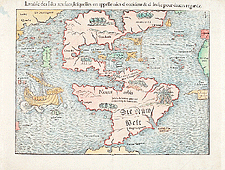
the great cartographers of Europe, such as Sebastian
Munster, predicted that it was nothing more
than a narrow strip of land. But, once they realized
just how far apart the two continents really were,
European adventurers of the seventeenth century
began searching for a water route that might lead
them around or through this great obstacle. The
Northwest Passage became one of the most powerful
geographical ideas of all time - a Holy Grail
in Europe's quest for the untold riches of Cathay.
With the English concentrating on more northerly
approaches to the Northwest Passage, exploration
of the western interior in the early-eighteenth
century was left largely to the French. Their
westward movement was fuelled by two major factors:
their desire to check the flow of furs heading
north to the English on Hudson Bay, and their
continuing search for an inland waterway that
was rumoured to lead to the Pacific.
The inland sea was first given credibility by
Samuel de
Champlain. In one chance meeting he had with
some Aboriginals while exploring the upper Great
Lakes, he heard of a great inland sea which extended
south and west of Hudson Bay, its icy waters covering
much of the Canadian Prairies.
After Champlain's death, the French search for
the western sea did not resume until the late-1720s,
when the Sieur de La Vérendrye took command
of the French settlements at Kaministikwia, Nipigon,
and Michipicoten. His interest centred on the
string of lakes
and rivers west of Lake Superior, now known
as the Lake of the Woods. First Nations from this
area told him of a river that flowed straight
west to a great inland lake called Lac Ouinipique
(Stinking Water). Another river supposedly continued
from this lake and discharged into a large ocean.
La Vérendrye
concluded that this ocean was the Pacific, and
cartographer Philippe
Buache predicted that the final discharge
would be somewhere north of California.
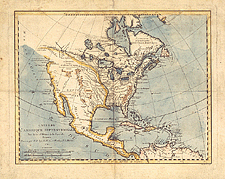
Europe's most fanciful Northwest Passage, however,
was based on the publication of the voyages of
the Spanish Admiral de Fonte who supposedly sailed
up the west coast of the Americas in 1640. De
Fonte claimed to have found the route at 52 degrees
north (near present-day Prince Rupert). Spain
dismissed de Fonte's claims, but the English and
French
took them seriously and readily incorporated his
fabricated descriptions into their maps.
Further
Readings
See also
> Next Theme: Fur
Trade
|